|
Days 15 - 18
Total for section: 72.6 Km
in 4 days
As in the previous section, accommodation
during this period is easy to find and it is suggested that
days 15 - 18 be walked on four consecutive days, using
accommodation suggested on the accommodation page. It is impossible to reach either the
starting or finishing points by public transport so arangements
will need to be made for dropping and collecting you.
The route details for any of the 24 days may be quickly found by
going to the route map page and
clicking the right spot on one of the maps. Then use the browser's back
arrow (top left if you are using Explorer) to return to the map
page to locate further days' route details.
Rights of Way
Virtually all the route described below lies on legal or
permissive rights of way (the few bits that don't, cross open
moorland where there is Right to Roam). This means that no one
can legally stop you from following the route although you could meet
temporary diversions.
As you may already know from bitter experience,
not all rights of way shown on the map can be easily followed. Some parts
of the pre-2010 route have become densely vegetated, bridges are
broken down and farmers have placed illegal barbed wire to prevent cattle
from straying.
After re-walking the whole route in 2010, I have
therefore extensively revised the route details in the light of
changing circumstances. The entire route described below can be
followed at present (January 2011) and where there
are special difficulties they are mentioned in the accompanying
notes.
There will be places where an inviting looking right of way
shown on the map appears to offer a better way than the one suggested.
Tigers will probably succeed but try them at your own risk.
If you are
successful, or if you have any other comments to make, please email me,
Michael Slaney, by clicking here
Day 15 - Esgair Hir old
mine to Machynlleth
distance from St David's 260.3
Km
| start at Esgair Hir old mine |
SN
732 912 |
| forest/miners' track |
3.0 |
Angler's Retreat |
746 923 |
| track |
1.7 |
Llyn Penrhaiadr N end |
754 935 |
| cross country |
0.6 |
miners' track |
759 934 |
| miners' track |
0.7 |
Hafodwnog |
763 938 |
| track |
2.9 |
Bwlch y groesen |
767 956 |
| keep on north west |
2.3 |
Mynydd Bach |
756 972 |
| track via Bwlch |
0.7 |
Bryn Coch Bach |
754 977 |
| track steep NNW |
0.5 |
forest |
756 980 |
| track in forest along ridge |
1.5 |
forest exit near Parc |
757 964 |
| path NNW |
1.5 |
near industrial estate |
754 006 |
| minor road = Glyndwr's Way |
0.5 |
A489, Machynlleth |
751 008 |
| A489 |
0.1 |
Maenllwyd Guest House |
751 008 | |
The charm of today's fairly short walk lies in the
gradual transition from wild mountain scenery to civilization in the
shape of the quite large town of Machynlleth.
There are no
serious route finding problems until Bwlch y groesen,
although the section marked "cross country" is a trackless link
joining two clear tracks. However, take great
care at Bwlch y groesen, where many tracks meet. The
correct one is outside the wood, going fairly steeply uphill.
The scenery as you approach Machynlleth
is very good, particularly, perhaps, near Mynydd
Bach.
You may not find exactly the route we found as you
approach the town but it will not matter much.
|
total for day 16.0 Km
distance from St David's 276.3 Km
Day 16 - Machynlleth to
Abergynolwyn
distance from St David's 276.3 Km
| start at Machynlleth, probably Maenllwyd Guest
House |
SH
751 008 |
| A489 |
0.6 |
Machynlleth clock |
745 008 |
| A487 |
1.4 |
Dovey bridge |
744 020 |
| A493 |
0.3 |
turn off on right |
741 019 |
| lane |
0.9 |
Cwm Gila |
736 022 |
| lane, bearing 350 |
0.9 |
enter forest*** |
733 028 |
| forest tracks |
1.6 |
Pantyspydded (ruin) |
728 040 |
| forest tracks |
2.0 |
forest exit |
720 055 |
| see notes* |
2.0 |
Pont Llaeron |
701 049 |
| path/old road |
2.2 |
Hendrewallog |
687 063 |
| track, surfaced road |
1.3 |
Abergynolwyn |
677 069 |
| road through village |
0.3 |
Riverside Guest House |
676 072 | |
Leaving Machynlleth on a main road is not
much fun but unavoidable. This is the worst traffic you will meet on
the whole route.
Once in the forest make for
Pantspydded, ***Navigaation in the
forest can be confusing and a GPS is exremely helpful as the
work going on seems to create diversions and
uncertainties. Take care or you will waste a lot of time.
*On
emerging from the forest go uphill keeping close to the forest
boundary, climb over the fence and re-enter it when you see a clear
path. This will then take you to the delightful bridge of Pont
Llaeron.
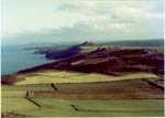
As you descend, Abergynolwyn looks
most inviting. See the picture.
The station of Nant Gwernol just before reaching the village is
worth a look. After visiting the station a pleasant path follows the
stream on the opposite side to the station and takes you quickly to
the village. |
total for day 13.5 Km
distance from St David's 289.8 Km
Day 17 - Abergynolwyn to
Barmouth
distance from St David's 289.8 Km
| start at Abergynolwyn |
SH
677 072 |
| minor road North |
4.6 |
Pennant farm |
674 096 |
| bridleway via Gwastadfryn |
3.4 |
Hafotty Gwastadfryn |
678 123 |
| path |
2.8 |
col (Cader Idris 2 Km) |
691 135 |
| Pony path |
2.0 |
road, turn left |
698
152 |
| minor road |
2.1 |
path off right |
678 145 |
| path past Llyn Cregennen |
1.3 |
road at far end |
659 146 |
| winding gated road |
1.8 |
Arthog falls |
648 145 |
| path beside falls |
0.3 |
Arthog |
646 146 |
| road through Arthog |
0.8 |
bridleway off right |
638 143 |
| bridleway |
0.2 |
old railway |
638 144 |
| old railway bed |
1.3 |
Morfa Mawddach Stn |
628 142 |
| Barmouth railway bridge |
1.7 |
Barmouth |
619 155 |
| road |
0.4 |
Bryn Melin Hotel |
620 158 | |
A great day's walk, particularly if you have the
energy to include the summit of Cader Idris by going right at 691
135, following the easy ridge for just over 2 km and therefore
adding slightly more than 4 km to the day's distance When deciding
whether to do this or not, bear in mind that the detour involves an
ascent of 300 m but that the rest of the day, though quite long, is
easy with not much more up-hill.
The rest of the day is full of
interest. A delightful lunch spot is reached at 699149, just befor
reaching the road at 698152 and Arthog falls are delightful. The
Barmouth railway bridge gives a romantically beautiful view of the
Mawddach estuary (see the
picture) |
total for day 22.4 Km
distance from St David's 312.2 Km
Day 18 - Barmouth to Llyn Cwm
Bychan
distance from St David's 312.2 Km
| start at Bryn Melin Hotel |
SH
620 158 |
| minor road |
3.5 |
Sylfaen |
632 185 |
| track |
2.2 |
path crossing |
638 203 |
| path |
2.3 |
Cairn (alt 572m) |
638 224 |
| path on old coach road |
2.1 |
Pont Scethin |
634 236 |
| bridleway |
2.7 |
Road in Cwm Nantcol |
631 257 |
| minor road |
2.7 |
Nantcol |
640 273 |
| tough going |
2.7 |
Llyn Gloyw (south end) |
647 297 |
| see the notes |
2.5 |
Llyn Cwm Bychan |
646 316 | |
The long Rhinog ridge has a fearsome reputation
and the next two days offer a delghtful milder alternative to the
whole ridge walk from Barmouth to Trawsfynydd in one day which
tigers can happily manage if they wsh.
Before reaching Pont
Scethin, an extraordinary bridge in the middle of nowhere (see the picture) you pass a stone saying
"Courage Traveller", a timely piece of encouragement.
After
walking out of Nantcol, the terrain suddenly changes completely and
becomes really difficult - the Rhinog boulders and heather - you
will find progress slow and you can make things easier if
you stay 100 metres or so east of Llyn Gloyw instead o following the
lake's east bank. It is a beauiful and wild spot.
|
total for day 20.7 Km
distance from St David's 332.9
Km
|